A Winter Weather Advisory remains in effect for the Uintas and Wasatch Mountains north of I-80 until Monday morning, as snow continues to impact higher elevations across northern Utah.
Most mountain areas are expected to receive 2 to 6 inches of snow, while the Bear River Mountains, located near the Utah-Idaho border, could see up to 10 inches by the end of the storm.
Cold Front Brings a Sharp Drop in Valley Temperatures
While the heaviest snow will remain in the mountains, residents in the valleys should prepare for a noticeable temperature drop.
Daytime highs are forecasted to range between the upper 40s and low 50s on Monday and Tuesday, marking one of the coldest starts of the season for many communities.
Monday Morning Outlook: Winds and Light Showers
By midday Monday, the final wave of moisture will move out, leading to a gradual decrease in showers across the region.
However, breezy northwesterly winds are expected to persist through much of the morning, adding a chill factor to the already cold air mass settling in.
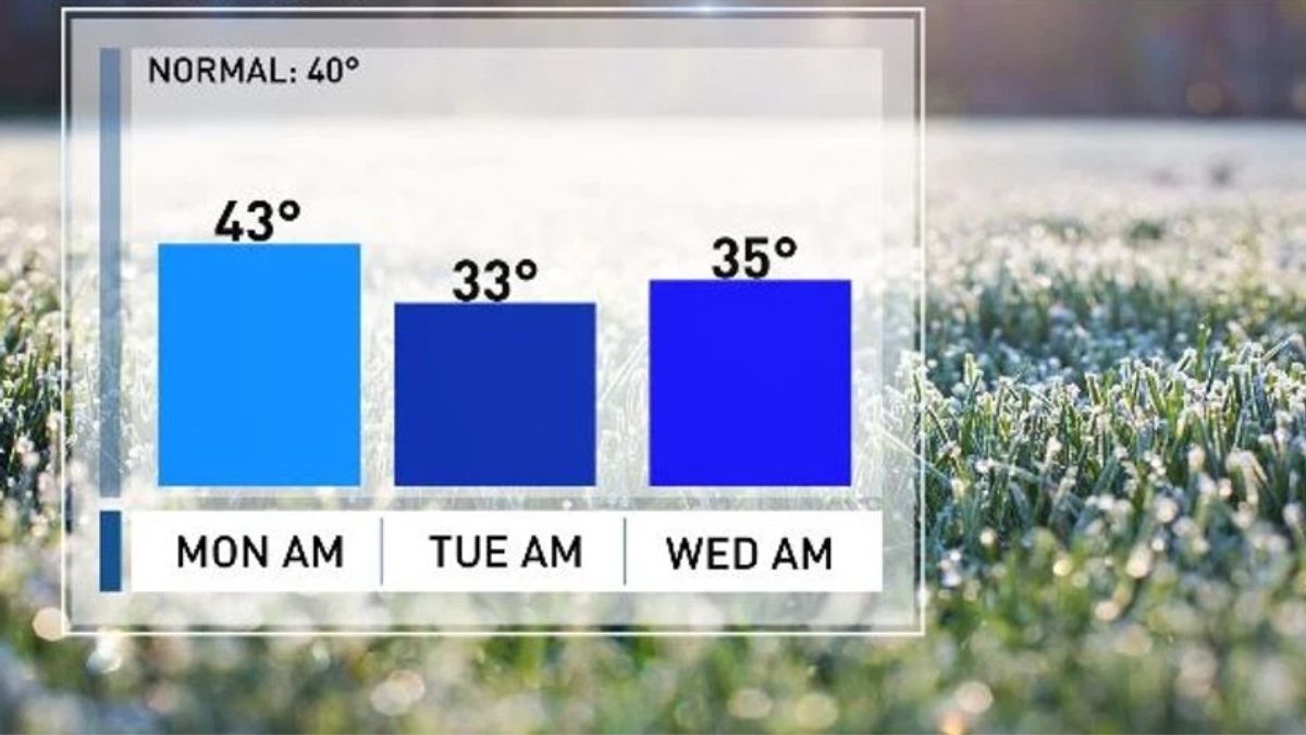
First Official Freeze Possible for Salt Lake City
Residents of Salt Lake City may experience the first official freeze of the season early Tuesday morning.
This arrival is about one week later than normal, signaling that autumn conditions are transitioning quickly into early winter patterns across northern Utah.
The coldest temperatures so far this year will settle in, urging locals to protect outdoor plants, cover water lines, and prepare for icy morning commutes.
Key Weather Highlights
| Weather Factor | Expected Conditions | Timing |
|---|---|---|
| Snowfall in Mountains | 2–6 inches (6–10 near Utah-Idaho border) | Through Monday morning |
| Temperature Drop in Valleys | Highs in upper 40s to low 50s | Monday–Tuesday |
| Wind Conditions | Breezy northwesterly winds | Monday morning |
| Showers End | Gradual tapering off | Midday Monday |
| Freeze Warning | Possible first freeze of season | Early Tuesday morning |
Preparing for the Cold Snap
Meteorologists are advising residents to take precautionary measures ahead of the Tuesday freeze. Ensure that pets, plants, and pipes are protected from freezing temperatures. Commuters should also be aware of possible slick roads in the early hours due to lingering moisture and frost.
Northern Utah is set to experience a true taste of winter, with mountain snow, falling temperatures, and chilly winds dominating the start of the week. While this system will move out by Monday afternoon, the cold air will linger, making Tuesday morning the coldest of the season so far. Stay prepared, stay warm, and keep an eye on updated weather forecasts for any changes.