Mount Rainier, one of the most iconic peaks in the Pacific Northwest, is more than just a beautiful snow-capped mountain — it’s also one of the most dangerous volcanoes in the United States. While Mount St. Helens often grabs headlines for its massive 1980 eruption, fewer people know about Mount Rainier’s silent but deadly past. About 500 years ago, a powerful lahar — a volcanic mudflow — known as the Electron Mudflow destroyed everything in its path, including what is now the town of Orting, Washington. Today, millions live under the shadow of this sleeping giant, unaware of the very real risk it still poses.
Mount Rainier: A Beautiful but Active Volcano
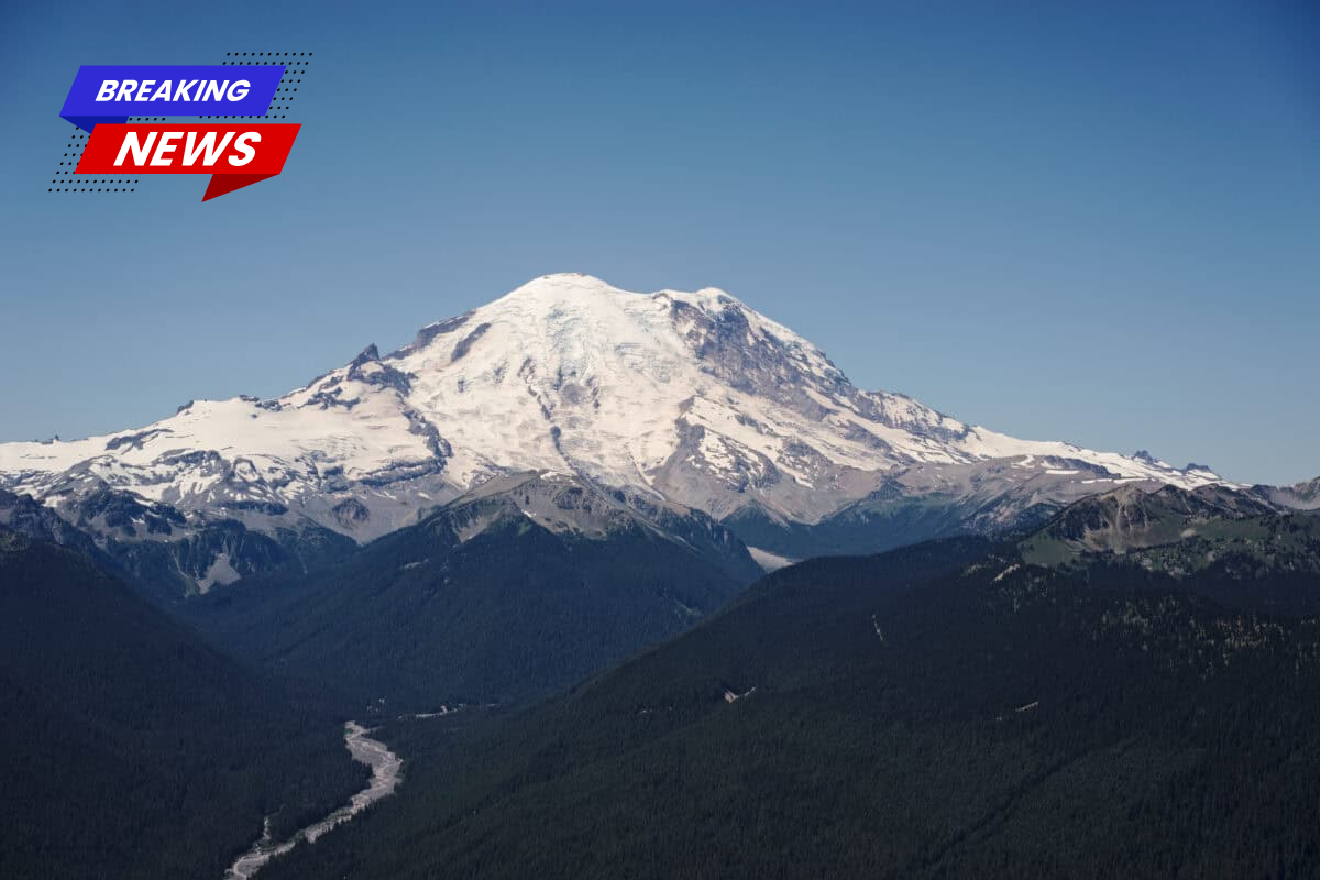
Rising to 14,411 feet, Mount Rainier is the tallest mountain in Washington and the most heavily glaciated volcano in the lower 48 states. It may look calm, but it’s an active stratovolcano, with a history of eruptions and disasters going back over half a million years. The most recent eruption occurred in the 1840s, but the real danger lies in what you can’t see — the possibility of deadly lahars triggered by volcanic heat melting its massive glaciers.
Rainier has over 25 glaciers, holding more ice than all other Cascade volcanoes combined. If that ice suddenly melts due to volcanic activity, it can mix with ash and rock to create a fast-moving mudflow that destroys everything in its path.
The Forgotten Disaster: The Electron Mudflow
About 500 years ago, a section of Mount Rainier’s west side collapsed, creating the Electron Mudflow. This wasn’t caused by a major eruption but likely by a landslide or internal heat weakening the rock. The resulting mudflow sped down the mountain at nearly 45 mph, travelling more than 30 miles and burying parts of the Puyallup River Valley in 20 feet of mud.
Evidence shows that indigenous settlements were completely wiped out in the disaster, including the area now known as Orting. The lahar was later named after the small town of Electron, where its deposits were first studied.
Indigenous Memory and Respect for the Mountain
Long before geologists named the mudflow, Coast Salish tribes like the Puyallup and Nisqually shared stories passed down through generations about the “angry mountain” and rivers turning to mud. These oral histories, once dismissed by early settlers, have now been shown to match scientific findings.
The names “Tahoma” or “Tacoma” for Mount Rainier translate to meanings like “mother of waters,” showing deep cultural ties and respect. The Electron Mudflow didn’t just change the land — it disrupted the lives and histories of the people who lived there.
What Exactly Is a Lahar?
A lahar is a dangerous volcanic mudflow made when hot rock or ash melts snow and ice, creating a fast-moving mix of water, mud, and debris. They move like wet concrete and can sweep away entire buildings, trees, and cars.
While some lahars are triggered by eruptions, others — like the Electron Mudflow — can be caused by heavy rain, earthquakes, or structural collapse without warning. With Mount Rainier’s huge glaciers and history of collapses, lahars are a very real threat to people living downstream.
Orting: A Town Built on Ancient Danger
Today, Orting, Washington is home to about 8,000 residents. It sits directly on top of the same mudflow that destroyed earlier settlements centuries ago. Scientists call this area a “lahar inundation zone,” meaning it could be hit again if Rainier releases another mudflow.
Local schools practice lahar evacuation drills, and the town has mapped out emergency escape routes. But in a real event, people might have only 30 to 40 minutes to reach safety. Orting’s geography — surrounded by rivers with limited high ground — makes fast evacuation a challenge.
How Mount Rainier Is Monitored
After Mount St. Helens erupted in 1980, scientists increased monitoring of other Cascade volcanoes. The USGS Cascades Volcano Observatory now watches Mount Rainier closely using:
- Seismometers for earthquakes
- GPS and gas monitors
- Stream gauges
- Acoustic flow monitors for lahars
These tools can automatically trigger warning sirens in places like Orting. However, sudden events like flank collapses could still happen too quickly for full evacuation.
Other Communities Also at Risk
It’s not just Orting. Cities like Puyallup, Sumner, Fife, Auburn, and even parts of Tacoma sit on ancient mudflows. The Port of Tacoma and Interstate 5, major economic and transportation hubs, are also within potential lahar zones.
Evacuating these areas during a major lahar would be extremely difficult, especially during peak hours. Emergency planners continue to develop strategies, but the risks remain high.
The Osceola Mudflow: Rainier’s Worst Event Yet
The Electron Mudflow was huge, but it’s nothing compared to the Osceola Mudflow that happened around 5,600 years ago. That lahar released 0.7 cubic miles of mud, reaching all the way to Puget Sound and changing the land near Auburn and Kent forever. It shows just how powerful and far-reaching Rainier’s lahars can be.
Mount Rainier National Park: Beauty Meets Risk
Every year, over 2 million people visit Mount Rainier National Park to see its stunning meadows and glaciers. But many don’t realize they’re walking on ancient lahar deposits.
The park has evacuation plans, and rangers talk about safety, but most focus on short-term dangers like avalanches or hypothermia rather than volcanic activity. Still, for scientists, the park is a valuable place to study Rainier’s history — and possibly predict its future.
Is Another Eruption Coming?
Experts agree it’s not a question of if, but when Mount Rainier will erupt again or trigger another lahar. It has a pattern of erupting every 500 to 1,000 years, and signs like small earthquakes, gas releases, and steam vents show that the volcano is still active.
Climate change is also affecting the glaciers, which could increase the risk of collapse. Even a small eruption could cause a major mudflow if it hits the right spot.
Living with the Risk: Why People Stay
You might wonder why people continue living in such a dangerous area. The answer is complicated. Some people are drawn to the mountain’s beauty. Others stay because land is more affordable in high-risk zones. Over time, many forget the danger — a phenomenon experts call “hazard amnesia.”
Local governments are working on stronger building codes, emergency drills, and public education. But at the end of the day, nature has the final say — and Mount Rainier has shown what it’s capable of before.